


By listening to what heritage sites have to tell us about character and history, we can build better and more sustainable places, writes Georgina Bignold

As architects and urban designers, responding to society’s growing housing needs while honouring the ancestry of heritage sites is always a challenge. At Proctor and Matthews, we have evolved a way to design new neighbourhoods that respond to their heritage context.
In introducing new developments on sites such as the Impney Estate in South Worcestershire, the landscape heritage of the Lowood Estate in the Scottish Borders and the archaeological heritage found at Northstowe, we draw inspiration from local heritage to ensure the new buildings not only value but also enhance the cultural substance of these sites.
The process behind this heritage-led placemaking involves context analysis of the site and its wider locality, undertaken through a dynamic mix of site visits and academic research. Sources of inspiration include the study of topography, geology and landscapes, to morphology, grain, street patterns, down to local historic vernacular and industrial building types, architectural features and detailing.
Our sources range from archaeology reports, conservation area reports and Historic England listings, to historical texts, maps, and artworks to better understand the historical significance of a site. In the course of this context analysis, many of the findings interrelate, and come to play a significant role in the design process, from masterplanning to material selection, so that places come to exhibit the distinctive characteristics of their locality on many, interconnected levels.
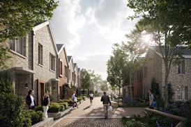
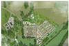
Within ambitious plans to reinvigorate the historic Impney Estate, north of Droitwich Spa we have masterplanned and designed the new village of Little Impney, set in the grounds of Impney Hall. Built by the industrialist John Corbett, the Hall was designed in the flamboyant Louis XIII style by the French architect Auguste Tronquois and the English architect Richard Phene Spiers. An existing disused conference centre built in the 1970’s will be demolished as part of a wider strategy by LDA Design to improve the setting of the original Hall and its potential future use as a boutique hotel.
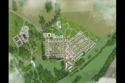
Our design narrative for the creation of a new planned village at Impney focuses on understanding the distinctive topography of the site, while being cognisant of the historical evolution of the estate layout. We have also given careful consideration to the relationship between the Hall and village that is evident in many historic precedents built across the country from the sixteenth to the nineteenth centuries.
At Impney, we were particularly intrigued by the notion of creating a new planned village inspired by the geometric layout of the 19th century walled productive garden. Although long-since demolished, the footprint of the wall remains, and by reinterpreting historical precedent of inhabited walled gardens, we designed homes that rise out of an enclosing village wall with an articulated arrangement of house gables, creating a distinctive village silhouette.
The character here is one of a formal geometric “parterre” of courtyard homes (with on-plot parking) arranged across two distinct terraced levels (referencing the formal gardens of Impney Hall). Tree lined avenues and shared surface squares and mews converge around a conservatory for vines: a nod to the glazed structures that lined the original kitchen garden wall.
In contrast, the new settlement to the east, whilst still displaying a compact village-scale orthogonal structure, is aligned to three east-west streets running along the hillside contours. This is crossed by “green lanes” – predominantly pedestrian priority routes which cascade down the hillside connecting the parkland to sustainable drainage water retention basins and pedestrian footpaths beyond.
The bridleway, John Corbett Way, divides these two distinctive areas of Little Impney and we located the estate square at this pivotal point. Created with a mixed-use focus, the space allows for residents and those working in the surrounding existing workshops to interact.
For the Lowood Estate, we prepared a masterplan for the Scottish Borders Council and the Borders Railway Blueprint exploring the potential expansion to the existing settlement of Tweedbank, generated by the opening of the new Borders Railway. The design utilises the natural topography of the site and looks to maximise the regenerative potential of the railway infrastructure with minimal visual disruption to the iconic landscape of the River Tweed valley.
From studying historic maps, we revealed a hidden part of the ancient riverbed topography to form a landscape armature, providing pedestrian and cycle route connections between the historic Lowood bridge, the proposed parkland business pavilions, the new station square, proposed residential woodland clusters and Tweedbank itself.
Historic precedents of bastle houses, sheilings, stells and even the distinctive orthogonal warp and weft of local estate tweed fabrics provide inspiration for the form and identity of the new housing, which is configured as a series of medium density hamlets. These are camouflaged within the footprint of existing commercial tree plantations and hidden from view by the existing plantation shelterbelts of deciduous trees.
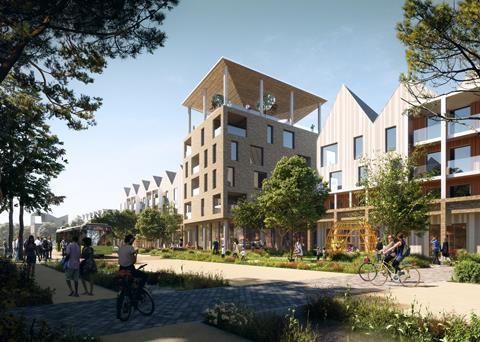
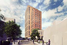
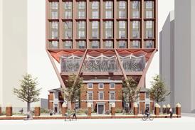
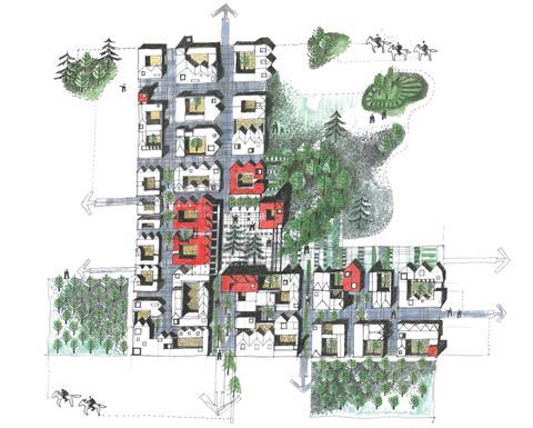
Northstowe in contrast, is a disused RAF WW2 airfield. We were commissioned by Homes England originally to prepare the design for the first parcel of the second phase (approx. 400 homes) as a guide to future development, and subsequently we submitted a planning application for Urban Splash.
Extensive archaeological investigations revealed centuries of human habitation across the disused airfield, with evidence of Bronze Age, Roman and Medieval structures and field enclosures. The design for Inholm in Northstowe, is inspired by the form of early roundhouse structures and the historic edge–of–Fenland settlements that were typically set on high gravel ridges and defined by a defensive perimeter and ditch boundaries.
The sustainable urban drainage strategy follows this Fenland precedent, and the quarter is surrounded in most part by swales. The “edge house” typology forms a contemporary inhabited boundary to the settlement with a staggered silhouette defining the landscape of the outer edge and the inner protected streetscape.
Threshold and entry points are marked by key buildings located strategically around the perimeter, while archaeological fragments and discoveries found at Northstowe inform the narrative behind the brick entrance arches and portals throughout the scheme.
These free-standing elements frame entrances and create boundaries, resulting in a unique silhouette and streetscape. For example, a tall mixed–use building with studio office space and ground level corner shop is intentionally angled against the grid, providing a distinctive silhouette to the quarter, which draws on the positioning studies we explored of churches situated in local villages.
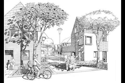
Placemaking in heritage contexts can be challenging, but by working with the spirit of a place, and not against it, the research process begins to organically inform the urbanism and architecture. By drawing inspiration from existing buildings, landscapes and archaeology, we believe that it’s not only possible to preserve the innate charcater of any given location, but to actually enhance and celebrate what makes each individual place special.
Postscript
Georgina Bignold is a director at Proctor & Matthews


No comments yet