- Home
 Built environment sectors offer warm wishes and warnings to Burnham and Rayner
 Squire & Partners unveils plans for three-tower scheme on former Stratford Sphere site
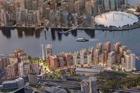 Gensler appointed to design first 1,500-home phase of revived Thameside West masterplan
 Rayner returns as housing secretary as Burnham sets out top cabinet jobs
- Events
Early bird tickets available now
Find out more
Events calendar
Explore now
Keep up to date
Find out more
- Programmes


City of London progresses new tower rules

Policy will specify ‘appropriate’ sites for structures above 75m and provide contour map for tall-building clusters
Proposals to rework the City of London’s planning policies in relation to tall buildings will see specific sites in the Square Mile identified as likely to be suitable for new structures above 75m in height, in a change from current rules.
A report to a meeting of the City’s Local Plans Sub (Planning and Transportation) Committee said the City Plan 2040 blueprint for development would amend the current local plan document to provide more clarity on acceptable sites for high-rise buildings – rather than identifying unsuitable sites.
The report said consultation work on the draft plan included observations from Mayor of London Sadiq Khan, who criticised the City’s current approach for being at odds with the capital-wide London Plan, which calls for boroughs to set out suitable sites for towers and “appropriate” heights.
…
This content is available to registered users | Already registered?Login here
You are not currently logged in.
To continue reading this story, sign up for free guest access
Existing Subscriber? LOGIN
REGISTER for free access on selected stories and sign up for email alerts. You get:
- Up to the minute architecture news from around the UK
- Breaking, daily and weekly e-newsletters
Subscribe to Building Design and you will benefit from:

- Unlimited news
- Reviews of the latest buildings from all corners of the world
- Technical studies
- Full access to all our online archives
- PLUS you will receive a digital copy of WA100 worth over £45
Subscribe now for unlimited access.